Join the one-day conference organised by the Copernicus Emergency Management Service (CEMS) taking place online on 13 October 2023. You're invited to a unique event showcasing...
Search results (9)
Showing results 1 to 9
Project/Activity
Copernicus Emergency Management Service (CEMS) Knowledge service topics
Copernicus products and services Knowledge service
Earth Observation Digital Europa Thesaurus
natural disaster
Online
Last year, the Copernicus Emergency Management Service (CEMS) launched the deployment of a new Aerial Component which operates in support of the Rapid Mapping and Risk and Recovery Mapping...
ECFAS builds on the CEMS framework to demonstrate the technical feasibility of a coastal flood awareness system and coast-targeted mapping products for CEMS Rapid Mapping as well as Risk and Recovery...

OBSERVER: The Copernicus Emergency Management Service (CEMS) Risk and Recovery Mapping component celebrates its 10th anniversary
Since then, the service has never stopped evolving to better serve its users and has become a reference in the emergency management ecosystem.
Information Bulletin 161 - The Copernicus Emergency Management Service delivers multi-risk analyses for Delphi and Ancient Olympia archaeological sites in Greece
In April 2022, for the first time since the beginning of its service, the Copernicus Emergency Management Service (CEMS) Risk and Recovery Mapping module has been activated to perform...

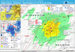
Information Bulletin 155 - CEMS activities supporting emergency management of the earthquake in Afghanistan
Between 22 and 25 June, the Copernicus Emergency Management Service (CEMS) Rapid Mapping analysed 13 areas localised in the provinces of Khost and Paktika.
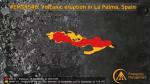
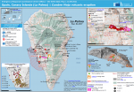
The Copernicus Emergency Management Service Provides Support in the Emergency Management of the Volcanic Eruption in La Palma, Spain
On 11 September 2021, the Copernicus Emergency Management Service (CEMS) Rapid Mapping was activated following the request of the Spanish General Directorate for Civil Protection and Emergencies...
More than a week after the Cumbre Vieja volcano erupted, satellite imagery has helped authorities monitor and manage the crisis.
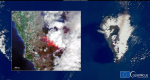
Satellites have been watching as the Cumbre Vieja volcano towering over the Spanish island of La Palma erupted for the first time since 1971 on Sunday.