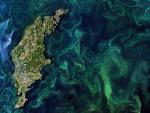
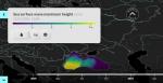
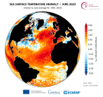
In this analysis, Copernicus Atmosphere Monitoring Service (CAMS) and Copernicus Climate Change Service (C3S) scientists conclude that it is too early to attribute the recent exceptional warming...
Search results (15)
Showing results 1 to 10
Knowledge service
Earth Observation Geographic coverage
Europe Digital Europa Thesaurus
Marine
The main purpose of this experiment is to mimic the geometry at which the Harmony satellites will measure various aspects of ocean dynamics to understand how air and the ocean surface interact.
A study published this week in Frontiers in Marine Science used Copernicus Marine data to show that the food-rich waters of the Bay of Biscay may be a deadly temptation for small...
A new ESA-funded research demonstrates how a specific way of processing satellite altimetry data can make it possible to determine sea-level change in coastal areas...
The workshop aims to bring together experts and users of marine products. It consists of a mixture of plenary expert talks, round table discussions and hands-on practical exercises...
Why is the ocean important? How is it monitored? The Copernicus Marine Service has developed a set of ‘ Ocean Explainers’ to answer these questions and many more.
A new report from the EU statistical office, relies heavily on data from the Copernicus Marine Service to map EUs progress across its SDGs. In the case of human interaction...
The Copernicus Marine Service has recently launched a significant update to its satellite wave products, which are vital for a wide range of blue ocean sectors...
This event will gather Copernicus marine communities such as partners and downstream users and showcase the road map for the future seven years.
Toulouse, France/Online
2nd Workshop in the CLEO (Colour and Light in the ocean from Earth Observation) Series.
Online