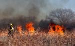
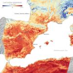
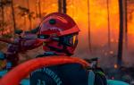
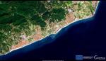
The EU is seeking to limit growing threats from blazes through the use of satellites, artificial intelligence and unmanned aerial vehicles. By combining satellite images and other data, the system...
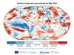
Search results (17)
Showing results 1 to 10
Knowledge service
Earth Observation Geographic coverage
Europe Digital Europa Thesaurus
Disaster management Knowledge type
News
As the 2023 wildfire season begins in Europe, the continent is confronted with the ever-challenging struggle to combat these devastating natural disasters. The rising global temperatures and the increasing frequency of extreme...
ECFAS builds on the CEMS framework to demonstrate the technical feasibility of a coastal flood awareness system and coast-targeted mapping products for CEMS Rapid Mapping as well as Risk and Recovery...
Scientists are using the Copernicus Sentinels to track the impacts of the searing heatwaves and fierce wildfires that are gripping parts of the continent this summer.
Already more than 515,000 hectares have been burnt across the EU, according to data from the European Forest Fire Information System (EFFIS).
This review focuses on three areas in particular, well covered by observations, which experienced much warmer-than-average conditions in the first half of 2022.
The European Coastal Flood Awareness System ( ECFAS) aims at creating a state-of-the-art solution to allow risk monitoring for European coastal zones.
A new processing chain is available on the Geo-hazards Exploitation Platform (GEP).
What has the actual situation been with windstorms over the past several decades? The C3S dataset provides winter windstorm indicators for 1979-2021 and contains climatological indicators...
Information Bulletin 151 - Mobilisation and Response of Copernicus Emergency Management Service for the Volcanic Eruption in La Palma (Spain)
50 years after its latest eruption, the Cumbre Vieja volcano on the island of La Palma, Canarias, Spain, entered into an eruptive episode on 19 September 2021...