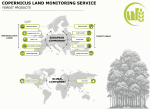
The European Union (EU) has taken significant steps to address the issue of deforestation and forest degradation, with the Deforestation Regulation (EUDR) and the proposed Forest Monitoring Framework being...
Search results (11)
Showing results 1 to 10
Knowledge service
Earth Observation Digital Europa Thesaurus
land use
Last October, the Copernicus Land Monitoring Service (CLMS) signed its next framework contract for production of the Urban Atlas product suite. Urban Atlas is CLMS’...
Wageningen University & Research (WUR) and Eurisy , with the support of StartHub Wageningen, organise this Hackathon on 23-24 October 2023 on the issue of “Spatial Data for Biodiversity”. The hackathon...
Ede, Netherlands
The new European Ground Motion Service provides free and accessible ground motion data to anyone who wishes to use it.
GNSS SBAS and Earth Observation Satellites Help Improve Farm Soil Drainage and Variable Rate Fertilization
Using in situ sensors, GNSS corrections and satellite remote sensing, it is possible to obtain information on soil anomalies, enabling farmers to take corrective actions in the field....
The Copernicus Climate Change Service (C3S*) has made the back-extension period of its high-resolution ERA5-Land reanalysis dataset available through the Climate Data Store (CDS).
With its wide range of applications, the EU space Copernicus programme can support Mexico and Central American countries in the post-pandemic economic recovery and in the management of natural and man-made...
Online
EO4IM (Earth Observations for Indigenous-led Land Management) aims to increase Indigenous peoples’ capacities to use EO to achieve their land management goals.
The event is open to everybody who is interested in this topic, but in particular it will add value to those who are considering using the data, be it for research...
Academics have undertaken research that proves Earth Observation satellite imagery can accurately assess the quality and quantity of some habitat types.