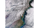
Record-breaking Arctic cold weather has swept through much of the United States in the last few weeks. The eastern part of the country was particularly affected with thick...
Search results (23)
Showing results 1 to 10
Knowledge service
Earth Observation Digital Europa Thesaurus
natural disaster
Join the one-day conference organised by the Copernicus Emergency Management Service (CEMS) taking place online on 13 October 2023. You're invited to a unique event showcasing...
Online
One of the world’s most active volcanoes, Mount Etna, erupted on Sunday – spewing lava and clouds of ash high over the Mediterranean island of Sicily. This image...
Last year, the Copernicus Emergency Management Service (CEMS) launched the deployment of a new Aerial Component which operates in support of the Rapid Mapping and Risk and Recovery Mapping...
ECFAS builds on the CEMS framework to demonstrate the technical feasibility of a coastal flood awareness system and coast-targeted mapping products for CEMS Rapid Mapping as well as Risk and Recovery...
OBSERVER: The Copernicus Emergency Management Service (CEMS) Risk and Recovery Mapping component celebrates its 10th anniversary
Since then, the service has never stopped evolving to better serve its users and has become a reference in the emergency management ecosystem.
As warmer air can hold more moisture, meteorologists were already warning earlier in the year that the extreme temperatures might result in higher than normal monsoon rains...
Information Bulletin 161 - The Copernicus Emergency Management Service delivers multi-risk analyses for Delphi and Ancient Olympia archaeological sites in Greece
In April 2022, for the first time since the beginning of its service, the Copernicus Emergency Management Service (CEMS) Risk and Recovery Mapping module has been activated to perform...
Information Bulletin 155 - CEMS activities supporting emergency management of the earthquake in Afghanistan
Between 22 and 25 June, the Copernicus Emergency Management Service (CEMS) Rapid Mapping analysed 13 areas localised in the provinces of Khost and Paktika.
Researchers have developed a way to use satellite imaging data to create 3D images that could quickly detect changes on the Earth's surface, a new study says.