The Data for Integration (D4I) dataset has been obtained through a spatial disaggregation of statistics of the 2011 Census, collected from National Statistical Institutes. The results of the spatial processing...
Search results (35)
Showing results 11 to 20
Geographic coverage
Portugal
The dataset contains information about how subnational geographical areas cluster with in terms of human mobility measured through Mobile Network Operator (MNO) data, irrespective...
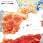
Satellite images show the temperature of the land surface in southern France, Spain and northern Africa in the morning of 17 July.
With EU Green Week on the horizon and in an exclusive video interview with European Research Executive Agency (REA), URBiNAT talks about the importance of social participation for co-creating cities...
The workshops have the overall objective to introduce and raise awareness of EO4GEO initiative to relevant stakeholder communities. Thus, it will identify current and future needs of EO/GI...
Online
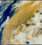
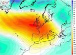
The Copernicus Atmosphere Monitoring Service predicted that this large-scale transport of Saharan dust would travel northwards, over many parts of western and central Europe, with dust concentrations...
Take a look at how farmers are coping climate change, what technologies they can use to make the most of the water they have and hear the bleak...
By connecting international governments to regional businesses, new international projects will be explored, addressing the potential of venture capital and public funding to the sectors that connect Space...
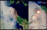
In particular, CAMS has been monitoring the intensity of wildfires in northern Portugal, where a number of fires burned for several days in late January and early February 2022.
OBSERVER: Unprecedented mobilisation of Copernicus EMS during the 2021 Mediterranean Wildfire crisis
Since the end of July, the forecasts of the Copernicus Emergency Management Service (CEMS) European Forest Fire Information System (EFFIS) had already predicted the likely development of fires...