Overview
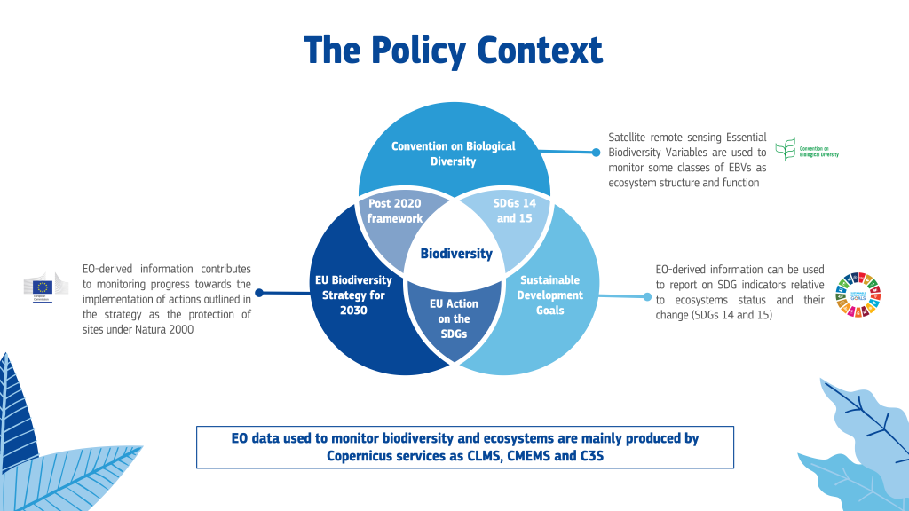
To preserve and support the restoration of Biodiversity, the diversity of life on earth and the variability among living organisms, within and between species and of ecosystems, the European Union has put forward its ambitious Biodiversity Strategy for 2030. It contains long-term plans and commitments to protect nature and ecosystems and it aims to set Europe’s biodiversity on a path to recovery by 2030. The EU Biodiversity Strategy for 2030 will help Europe lead the way in addressing the global biodiversity crisis by promoting the adoption of a global post-2020 biodiversity framework under the Convention on Biological Diversity and the achievement of SDGs specific targets on biodiversity under SDG 14 and 15, respectively on life below water and life on land. The need to protect and restore biodiversity is also at the core of the European Green Deal, marking the EU willingness and determination to address some of the most pressing challenges of our time.

Remote sensing and the services offered by the Copernicus program, in particular the Land Monitoring Service (CLMS), the Climate Change Service (C3S) and the Marine Service (CMEMS) have come to play an increasingly important role in support of biodiversity conservation and restoration. Today, products and tools offered by these services contribute to monitoring changes in ecosystems and biodiversity loss and are utilized in the context of the EU Biodiversity Strategy, the Convention on Biological Diversity and SDG reporting. A few, non-exhaustive examples are reported here.
EU Biodiversity Strategy and EO
As regards the Biodiversity Strategy for 2030, the EU aims to establish protected areas under Natura 2000 (N2K) for at least 30% of land and sea in Europe. N2K is a network of core breeding and nesting sites designated as protected areas under the Birds and Habitats Directives. The CLMS has developed a dedicated Natura2000 product (N2K product) to help monitor protected areas by mapping land cover and use in the selected sites and producing comparative analyses of the time series of the product that show the effectiveness of N2K as a legal protection. CMEMS ocean variables and monitoring indicators provide quality data on temperature, sea level, acidity and other phenomena that can be used to monitor marine ecosystems and to protect Marine Protected Areas (MPAs). Under C3S, the Sectoral Information System (SIS) in support of biodiversity derives climate-related information targeted at the biodiversity sector to understand climate change impact on biodiversity. Moreover, the EU Biodiversity Strategy calls for the establishment of an international natural capital accounting initiative, which the EU is developing through the Knowledge Innovation Project on Integrated Natural Capital Accounting (KIP INCA), making use of data on ecosystems services and conditions derived also from remote-sensing information.
Convention on Biological Diversity and EO
The Group on Earth Observations Biodiversity Observation Network (GEOBON) developed satellite remote sensing essential biodiversity variables (SRS-EBVs) to support a global biodiversity monitoring strategy under the Convention on Biological Diversity. The most recent satellite remote sensing sensors and in particular the Copernicus Sentinel family and its related services, enable to operationally monitor several of the SRS-EBVs. The CLMS provides indices useful for the monitoring of SRS-EBVs classes on ecosystems structures and functions looking at the structural and functional traits of ecosystems that lead to, and maintain, biodiversity characteristics such as forest cover, land cover, leaf area index, vegetation phenology and soil moisture.
Efforts to develop a global biodiversity monitoring system have suffered from a great heterogeneity of available indicators lacking global reach. This gap can be closed by increasingly relying on the continuous and open availability of satellite data characterized by high spatiotemporal resolution and increased integration with in situ observations.
Sustainable Development Goals and EO
In the case of the SDGs, CMEMS has been the first among the Copernicus services to produce an indicator relevant to the monitoring of SDG 14. In fact, the ocean acidification indicator looks at oceans pH with a view to understanding how oceans acidification and increased water temperatures, together with other environmental stressors, impact biodiversity loss. As regards SDG 15, Earth Observation derived indicators by the CLMS such as forest area and land use change can support reporting on the “protection, restoration and promotion the sustainable use of terrestrial ecosystems, sustainably manage forests, combat desertification, and halt and reverse land degradation and halt biodiversity loss”.
Knowledge Centre for Biodiversity and KCEO
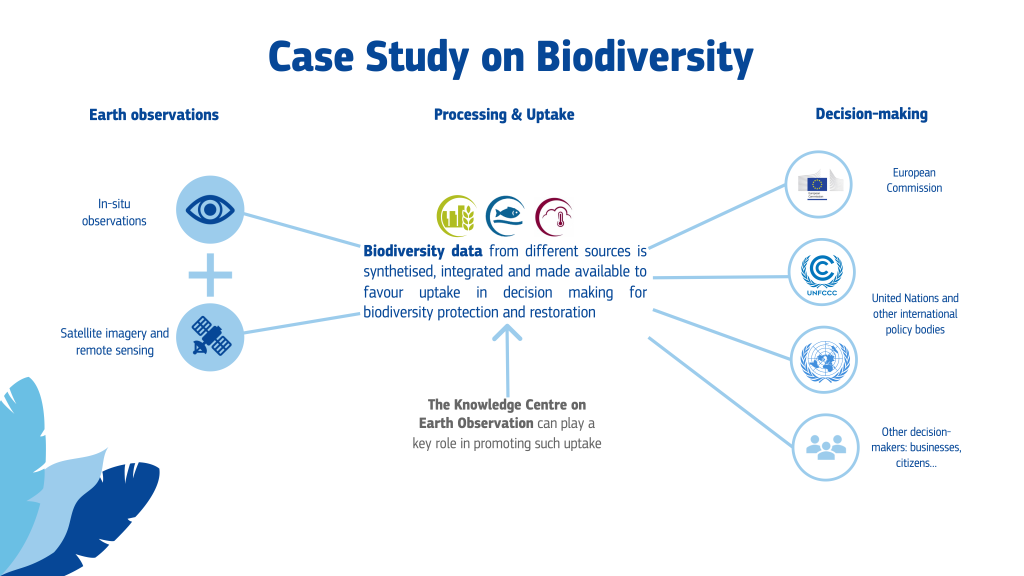
The European Union is facilitating access to biodiversity information through the European Commission Knowledge Centre for Biodiversity, which acts as a platform to monitor progress on the implementation of the EU Biodiversity Strategy, providing information, data and the knowledge necessary to achieve the goals set out in the biodiversity strategy. It also provides access to instruments as the Biodiversity Information System for Europe (BISE) and the Digital Observatory for Protected Areas (DOPA). Ultimately, the establishment of the Knowledge Centre on Earth Observation will represent another step towards the implementation of the EU ambitious plan to mainstream evidence-based decision making and promote the uptake of EO-derived information in the policy area of biodiversity.
Further Readings
Scientific papers:
| Originally Published | Last Updated | 13 Apr 2021 | 27 Apr 2021 |
| Knowledge service | Metadata | Earth Observation |