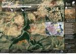
Following the devastating earthquake that struck Morocco on 8 September, satellite data have been made available through the International Charter ‘Space and Major Disasters’ to...
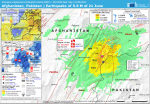
Between 22 and 25 June, the Copernicus Emergency Management Service (CEMS) Rapid Mapping analysed 13 areas localised in the provinces of Khost and Paktika.
The European Ground Motion Service (EGMS) is the latest offering of the Copernicus Land Monitoring Service that provides free and accessible ground motion data to any user.
A projection update analysis was conducted in Haiti in February 2022 to update the IPC Acute Food Insecurity projection originally released in September 2021, on the basis that new...
Exposure to natural hazards doubled in the last 40 years; earthquake affects the highest number of people; flood is the most frequent natural disaster; tropical cyclone winds...
To issue analysis report for every potential worldwide Tsunami event caused by earthquakes of Magnitude at least 7.0 Mw; the reports (1h, 3h and final report within...