Scientists are using the Copernicus Sentinels to track the impacts of the searing heatwaves and fierce wildfires that are gripping parts of the continent this summer.
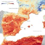
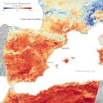
CAMS data show the highest FRP values in August 2022 come from the fire that burnt at least 3,600 hectares in Portugal’s Serra da Estrela, in the Castelo Branco...
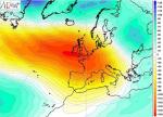
In particular, CAMS has been monitoring the intensity of wildfires in northern Portugal, where a number of fires burned for several days in late January and early February 2022.