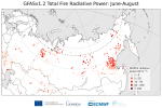
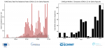
According to data from the CAMS Global Fire Assimilation System (GFAS), total wildfire emissions in the EU and the United Kingdom between 1 June and 31 August in 2022...
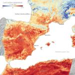
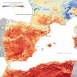
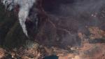
Scientists are using the Copernicus Sentinels to track the impacts of the searing heatwaves and fierce wildfires that are gripping parts of the continent this summer.
CAMS data show the highest FRP values in August 2022 come from the fire that burnt at least 3,600 hectares in Portugal’s Serra da Estrela, in the Castelo Branco...
The Joint Research Centre (JRC) of the Commission presented the 21th edition of its Annual Report on Forest Fires in Europe, the Middle East and North Africa, covering 2020.
The report provides a description of the fire season 2020 from the countries perspective and the same type of analysis from the European Forest Fire Information System (EFFIS)
This year, record-breaking wildfires triggered by similarly historic heatwaves are ravaging swaths of land on three continents and Earth observation satellites — some operated by space...
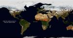
At the beginning of July, the ECMWF reported on the increasing number of large forest fires breaking out around the Northern Hemisphere. As the fires continue to blaze, here's a look at what...