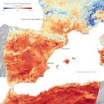
NEWS | 20 Jul 2022 Feeling the heat from space Satellite images show the temperature of the land surface in southern France, Spain and northern Africa in the morning of 17 July.
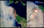
NEWS | 21 Oct 2021 OBSERVER: Unprecedented mobilisation of Copernicus EMS during the 2021 Mediterranean Wildfire crisis Since the end of July, the forecasts of the Copernicus Emergency Management Service (CEMS) European Forest Fire Information System (EFFIS) had already predicted the likely development of fires...