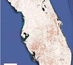
AI satellite mapping can quickly pinpoint hurricane damage across an entire state to spot where people may be trapped
By using satellite images from before the storm and real-time images from four satellite sensors, together with AI team of spatial and environmental analysts created a disaster monitoring system that can...