An innovative satellite data analysis method that delivers fresh insight into small water bodies in remote and complex landscapes has been developed as part of an ESA-backed project...
Search results (11)
Showing results 1 to 10
Project/Activity
Copernicus Climate Change Service (C3S) Geographic coverage
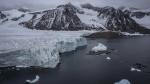
Arctic
During the EU Space Week in Sevilla, Spain, Mercator Ocean International announced the launch of the Copernicus Arctic and Coastal Thematic Hubs. These hubs aim to provide...
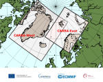
The Copernicus Arctic Regional Reanalysis (CARRA), a state-of-the-art, data-driven reanalysis from the Copernicus Climate Change Service (C3S) that allows a new scrutiny of the Arctic climate, is now being...
CAMS and C3S data contribute to the Arctic Risk Platform, a tool showcasing the global impacts of climate change at higher latitudes
In 2017 a team of scientists and science communicators came together around the Arctic Basecamp Project to encourage business leaders and policymakers to take bold climate action.

What a warming climate means for the Earth’s ecosystem and our way of life
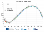
Last month saw the lowest extent of Antarctic sea ice on record for July, according to the European Union's satellite monitoring group.
Europe has the capacity to better understand the challenges the Arctic Circle is confronted with, shape new mitigating policies and develop the necessary tools to fight climate change

Europe experienced its warmest summer on record in 2021, accompanied by severe floods in western Europe and dry conditions in the Mediterranean.
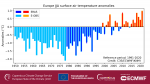
Europe experienced its warmest summer on record in 2021, accompanied by severe floods in western Europe and dry conditions in the Mediterranean.

Copernicus: Europe experienced a warmer than average February and winter; Daily sea ice extent around Antarctica reached its lowest value on record during February
All the reported findings are based on computer-generated analyses using billions of measurements from satellites, ships, aircraft and weather stations around the world.