The Food Systems Integrated Program (FSIP), led by FAO and IFAD, will direct $252 million in project financing and $2.2 billion in co-financing to 32 countries. The FSIP...
Search results (6)
Showing results 1 to 6
Geographic coverage
Pakistan Knowledge type
News Projects and activities
Working across South Asia, this Initiative aims to deliver a coordinated program of research and engagement across the food production–to–consumption continuum to support equitable access to sustainable healthy...
Overall description: to set up a system for the monitoring of the implementation of EU Readmission Agreements in third countries and the situation of readmitted persons through a pilot initiative in Ukraine and Pakistan.
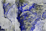
As warmer air can hold more moisture, meteorologists were already warning earlier in the year that the extreme temperatures might result in higher than normal monsoon rains...
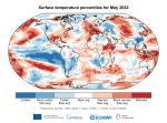
This review focuses on three areas in particular, well covered by observations, which experienced much warmer-than-average conditions in the first half of 2022.
"The interdependence between human health and planetary health has never been clearer. But time is fast running out. As we urgently seek to rescue the situation...