The Total Water Storage (TWS) Anomaly indicator that is implemented in the Copernicus Global Drought Observatory (GDO) is used for determining the occurrence of long-term hydrological drought conditions, which...
Search results (38)
Showing results 1 to 10
Digital Europa Thesaurus
water supply
Combined Drought Indicator (CDI) based on SPI, soil moisture and fAPAR, to identify areas with potential to suffer agricultural drought, areas where the vegetation is already affected...
EUMETSAT is stepping up its collaboration with African entities to enhance use of satellite data and products in the field of hydrology
Representatives from the African Union Commission (AUC), the Nile, Congo and Niger river basin authorities, national and regional institutions from South Africa, Senegal, Nigeria and East Africa...

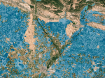
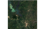
Like many countries in west Africa, Cote d’Ivoire is experiencing the effects of the climate crisis, such as drought. Earth observing satellites, such as Copernicus Sentinel-2, can help...
Highlights: A four-step planning framework for water-energy-food at the basin scale is developed. Detailed river basin simulation coupled with AI-driven optimization is implemented. The Grand Ethiopian Renaissance Dam...
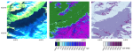
The Copernicus Land Monitoring Service has just released the latest update of its Persistent Snow Area (PSA) product for the hydrological year 2022-2023. The PSA product...
Snow cover is an important component of the Earth’s cryosphere and plays a significant role in regulating the Earth’s climate and hydrological cycle. Accurate estimates of snow cover are essential...
A paper published recently in the journal Earth System Science Data reports on the results of ESA’s Science for Society Irrigation+ project, which aims to show how irrigation...