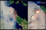
Scientists are using the Copernicus Sentinels to track the impacts of the searing heatwaves and fierce wildfires that are gripping parts of the continent this summer.
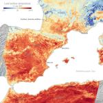
CAMS data show the highest FRP values in August 2022 come from the fire that burnt at least 3,600 hectares in Portugal’s Serra da Estrela, in the Castelo Branco...
Since the end of July, the forecasts of the Copernicus Emergency Management Service (CEMS) European Forest Fire Information System (EFFIS) had already predicted the likely development of fires...
CEMS Week brings together experts, users and policy makers to participate in a discussion about the future of our service and user community.Take part in live virtual-sessions and -workshops...
Copernicus Emergency Management Service (Copernicus EMS) provides information for emergency response in relation to different types of disasters, including meteorological hazards, geophysical hazards, deliberate...