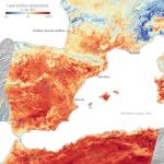
NEWS | 20 Jul 2022 Feeling the heat from space Satellite images show the temperature of the land surface in southern France, Spain and northern Africa in the morning of 17 July.
NEWS | 11 Oct 2021 La Palma volcano: How satellites help us monitor eruptions From capturing images of the rivers of lava, to measuring gas emissions and assessing damage, the fleet of Copernicus Sentinel satellites have been providing crucial data for local teams.
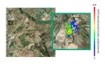
NEWS | 10 Nov 2021 Satellites detect large methane emissions from Madrid landfills High-resolution satellites have detected substantial quantities of methane leaking from adjacent landfill sites close to the center of Madrid, Spain.