Search results (37)
Showing results 1 to 10
Geographic coverage
Arctic
An innovative satellite data analysis method that delivers fresh insight into small water bodies in remote and complex landscapes has been developed as part of an ESA-backed project...
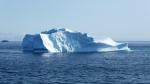
The Arctic is experiencing disproportionately higher temperature increases compared to the rest of the planet, triggering a series of cascading effects. This rapid warming has profound implications for global climate...
During the EU Space Week in Sevilla, Spain, Mercator Ocean International announced the launch of the Copernicus Arctic and Coastal Thematic Hubs. These hubs aim to provide...
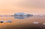
This year there was a drastic drop in sea ice on a global scale caused by a combination of the now usual major melting during the northern hemisphere spring in the Arctic...

The Arctic, once again at the forefront of climate change, is experiencing disproportionately higher temperature increases triggering a series of cascading effects known as Arctic amplification. Satellites developed...

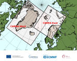
The Copernicus Arctic Regional Reanalysis (CARRA), a state-of-the-art, data-driven reanalysis from the Copernicus Climate Change Service (C3S) that allows a new scrutiny of the Arctic climate, is now being...
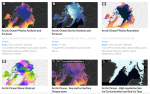
CAMS and C3S data contribute to the Arctic Risk Platform, a tool showcasing the global impacts of climate change at higher latitudes
In 2017 a team of scientists and science communicators came together around the Arctic Basecamp Project to encourage business leaders and policymakers to take bold climate action.
The workshop aims to address Polar resilience, the changing Arctic economy and not least the changing climate at both poles, and how Copernicus can support monitoring these...
Online
What a warming climate means for the Earth’s ecosystem and our way of life