Policy context
Anthropogenic emissions from agriculture, forestry and other land use (AFOLU) sector account for 14% of anthropogenic CO2 emissions, the large majority being from forestry. On the other hand, forests can provide 30% of the solution to keeping global warming below 2°C as outlined in the Paris Agreement, through carbon removal and storage from the atmosphere.
Reducing forest loss and degradation is a priority under the UN Strategic Plan on Forests. Strengthening efforts to manage forests sustainably is also central to the UN 2030 Agenda for Sustainable Development. SDG 15 target 15.2 , specifically promotes the implementation of sustainable management of forests, the halting of deforestation, the restoration of degraded forests and the increase of afforestation and reforestation globally.
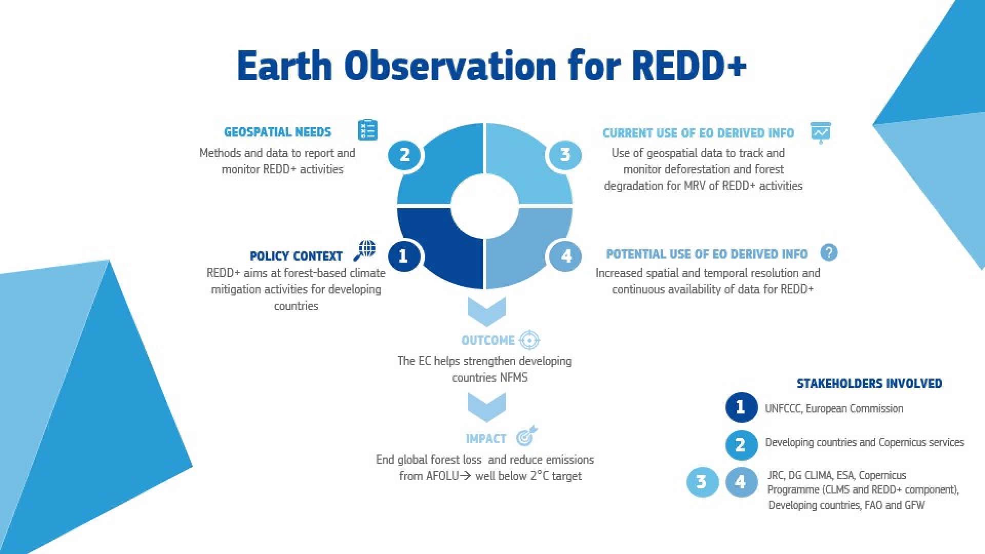
Deforestation happens mainly around the tropical belt and in 2007 the UNFCCC formalised REDD+, aimed at reducing emissions from deforestation and forest degradation in developing countries, recognising the role of conservation, sustainable management and enhancement of forests carbon stocks.
The 2019 Communication on Stepping up EU Action to Protect and Restore the World’s Forests mentions that the contribution of the Copernicus program and efforts to develop a Copernicus REDD+ service component are essential to promote the use of Earth Observations for strengthening global and developing countries’ national forest monitoring systems.
The European Union wants to ensure its actions and consumption do not result in deforestation within Member States and other areas of the world. To this end, in 2020 the European Parliament has developed a proposal for an EU legal framework to halt and reverse EU-driven deforestation.
The European Union, in particular through the Copernicus program and the work of the Directorate-General for Climate Action (DG CLIMA), can give an important contribution to the efforts of developing countries in the design of effective national forest monitoring systems, the development of methods to assess forest reference levels (FRLs) and the establishment of sound monitoring, reporting and verification (MRV) frameworks in the context of REDD+.
Overview of EO for REDD+
If on one side, the need for geospatial information and their use in the context of REDD+ is clear, the potential for increased uptake of EO-derived information is also extensive, especially, given the continuous evolution and improvement of products derived from the Copernicus services.

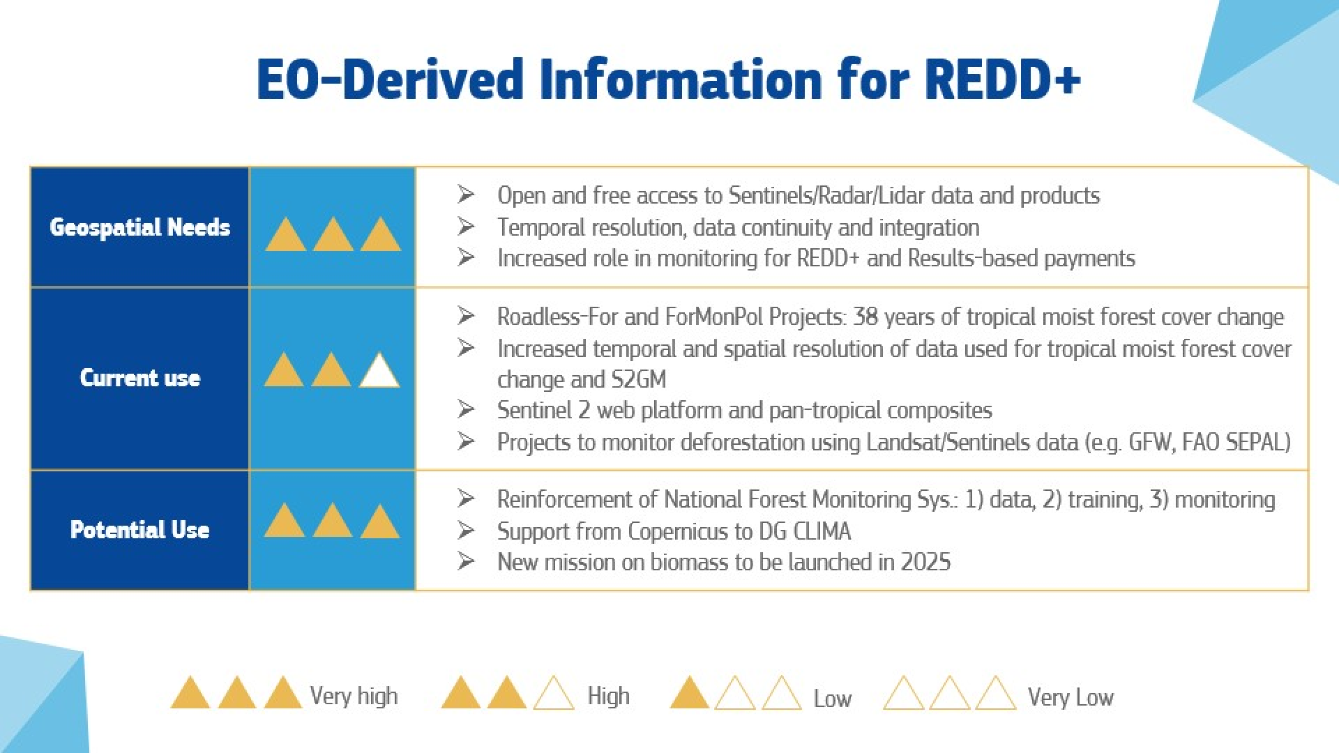
European Commission studies on REDD+ directly built on geospatial data are the Roadless-For pilot project ended in 2018, and Tropical Forest Monitoring component, on-going and part of the ForMonPol (Forest Monitoring for Policies) project.
The two projects have produced a new dataset on forest cover change in tropical moist forests (TMF) using 38 years of Landsat time series. The beneficiaries of the project include tropical developing countries, EU member states and the scientific community.
Needs, current and potential use of EO
Focusing on main geospatial needs, Copernicus Sentinel 2 data can be used to monitor forests for the purpose of MRV processes, by providing annual land cover maps time series. For REDD+, high temporal and spatial resolution data is key as vegetation in tropical ecosystems regrows quite fast and can hide forest disturbances at local scale or short-term effect. In the context of the ForMonPol project, the JRC produces tropical moist forest cover maps based on Landsat data at 30 metres resolution. Sentinel-2 composites at regular intervals over the tropical belt are openly made available for online analysis for REDD+ monitoring through the Sentinel-2 Global Mosaic Service and the JRC . Moreover the IMPACT Toolbox allows users to process forests data in an online GIS environment. Alternative products and analysis tools have also been developed starting from Landsat and Sentinels imagery by Global Forest Watch that provides an online platform to track global deforestation, FAO with its Sustainable Forest Management Toolbox (SEPAL) and other institutions as the Forest Carbon Partnership Facility.

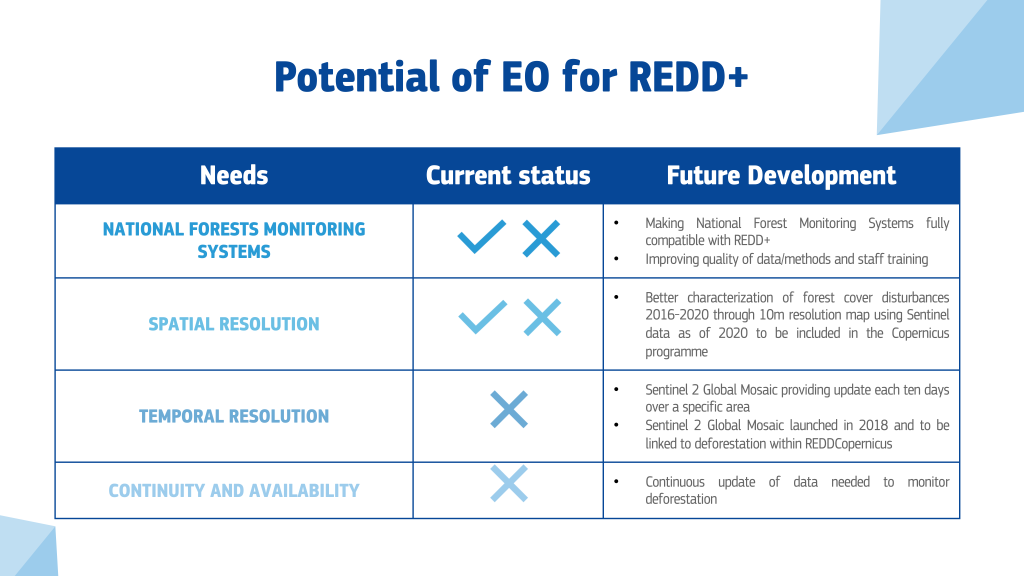
The potential for the uptake EO-derived products for REDD+ will increase, in particular, with the launch of the new biomass mission scheduled for 2025, but also thanks to the contribution of satellite imagery to monitor compliance with REDD+ schemes through the control of FRLs and MRV processes and thanks to the consolidation of the Copernicus REDD+ service component. Increased spatial and temporal resolution of data is also required to strengthen national forests monitoring systems. For example, use of Sentinel 2 data for the Roadless-For project instead of the currently used Landsat imagery enables reaching 10metres spatial resolution in 2020.

Sentinel 2 data has also been used to build global mosaics supporting monitoring activities for REDD+. This allows users to obtain images of higher temporal resolution based on specific needs, over any area of interest and in user-friendly formats. Key for the success of the European support to REDD+ through the provision of geospatial information is the continuous availability of open data on the status of forests worldwide and an increased capacity of developing countries to process such data. The European Union contributes to both objectives by supporting capacity building activities and fostering cooperation with developing countries also through the establishment of the EU Observatory on deforestation and forest degradation, facilitating access to information on forestry for public entities, consumers, and business.
Evolution of the EO value chain for REDD+

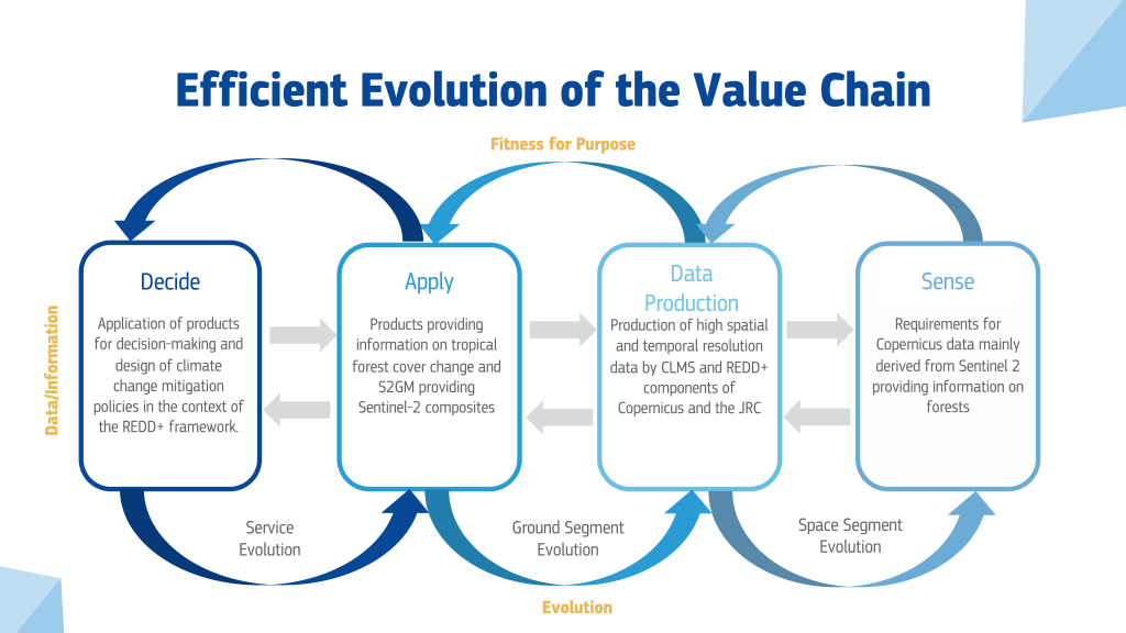
Overall, the current and potential use of Copernicus products for REDD+ shows how this service is becoming pivotal in the context of European and international policies aimed at halting deforestation and forest degradation through an increased use of EO-derived information. The preservation, sustainable management and enhancement of forests carbon stocks is among the cornerstones of the climate change mitigation strategy of the European Union.
Further readings
| Originally Published | Last Updated | 14 Apr 2021 | 02 May 2023 |
| Knowledge service | Metadata | Earth Observation | EU policies and Earth Observation |
Share this page
